Sunday, September 18, 2016

Day 3, how to you pronounce Antigonish?

We awake to the sounds of construction on a new pier not far from our room. It's interesting to watch as the workmen move the equipment down as the water recedes, with the 10-15 meter tides, they can work below the waterline for several hours until the tide rises. WE go down to the hotel lobby for our complimentary breakfast, which consists of Frosted Flakes, Raisin Bran, a loaf of white bread, a toaster and some juice. Pretty lame, these guys get a "thumbs down" on Trip Advisor.

We head out in the usual fog and drizzle taking the back roads up the coast, the views are really nice, we assume, because visibility is still about 100 meters...  oh well. At times the road heads inland and the fogs lifts, the country side is scenic, the road is fun as it twists and winds through the gentle hills.
Back on the coast we pass by "Hopewell Rocks", There's a fee to get in and we would have to walk and leave the bike. That's one problem travelling on the motorcycle, it's difficult to do things that involve leaving the bike for any length of time. But we are ok with that, the parking lot is full of cars and tour buses and we can do without the crowds. Maybe someday when we're too old to ride, we'll get a motor home and do the senior RV circuit.


We make our way to Moncton, there is a large contingent of military vessels in the harbor and a half dozen large military helicopters flying overhead, not sure why, but kind of neat to see. We take the hi-way east for a bit crossing from New Brunswick into Nova Scotia. Exiting the hi-way as soon as we can we find a nice route through farm country, the clouds have lifted, but we still get an occasional light shower. The roads are perfect for the motorcycle, weaving through valleys, following streams and rolling hills, very little traffic.

After we pass through New Glasgow we take the Sunrise Trail up towards Cape George Point. The road is nice and weaves in and out along the coast. We pass through the town of Malignant Cove, odd name for a town, and we opt not to stay there!
We had hope to find a B&B, motel or Inn along the Sunrise Trail, but it is very sparsely populated, and not much exists, so we head to the town of Antigonish.


Antigonish is a large town, and a college town. The St. Francis Xavier Colleg campus is fairly large and quite beautiful, and from what I van gather, has about a 3:1 ratio of women to men! We check out what we can find for accommodations, which are few and settle for The Maritime Inn, a hotel near the town center. Ready for a beer while we unpack, I head down to the hotel bar, the beer selection is pretty lame, as has been the case since we entered Canada. Somehow they haven't gotten into craft beers, and even a bottle of any kind of IPA is hard to come by. So I settle foe a bottle of Heineken for $7.50!!  Ouch

After a shower and a glass of wine, oh yeah, wine, that's another story. In New Brunswick and Nova Scotia, you can only purchase beer, wine and alcohol from the state run stores. So we've been picking up at least one bottle of wine for the evening anytime we pass a liquor store, and as you can guess it's expensive.  So anyway, we have a glass of wine and take a stroll downtown. We see a sign for the "Townhouse Pub", featuring craft beers!!  It's a nice little Irish style pub, and, they have good beer on tap!!  We enjoy a few beers, DeeDee has some wine and we check out the menu, pretty typical bar menu. We decide to walk about and find the liquor store. The weather is pleasant, on the warm side and lots of college kids about, mostly girls in summer attire... I get punched a few times. If anyone has a son going to college next year, I highly recommend St Francis Xavier!

Back to the room, another glass of wine and out we go for dinner. We settle on The Brownstone Cafe, a cute place on the main street with outdoor seating. The outdoor tables are all occupied so we are seated at a nice little table indoors. The food is great as is the service.
We never asked, so we still never quite figured how to pronounce Antigonish..

Saturday, September 17, 2016

Day Two, Always An Adventure

After our fantastic breakfast, we bid adieu to David and pack up the bike, it's kind of like a jig saw puzzle the first few days getting everything in the right place, and making sure the rain gear is handy

It's cloudy and some light drizzle as we head out, remnants of Hurricane Hermine. We ride for an hour or so through Saint John and then take back roads towards the coast,  The views are amazing, at least that is what we are told, the fog is thick, with visibility about 100 meters. (we're not in the U.S. any more, the only country on the planet not using the metric system!) we continue along the coast to the town of St Martins. We stop at a roadside stand for their specialty, a lobster roll and an order of hand cut fries, $23 !!  and it was the smallest lobster roll I have ever seen! Past the town along the coast we come to the Red Rocks, a series of large caves along the Bay of Fundy, very pretty, but the multiple tour buses and tourist traps kind of spoil the beauty.


The GPS says we can continue through the park on smaller roads towards our destination, Alma. a few miles down the road we come to a booth with a ranger collecting admission fees for the scenic route. I ask if the road goes through to Alma, nope, is the answer. I ask about alternative routs, she say we have to go back to the main road and up to Sussex. so we turn around. The GPS says there is another route around, it's about this time that I'm starting to wonder about my Garmin...  Off we go on yet another wild goose chase only to turn around again.  Back to the main road. About 10 kilometers up the road, there is a good road heading towards our destination, and this one is on the map, the GPS agrees. about 15 clicks (clicks to the savvy world traveller are kilometers) up the road the tarmac turns to dirt, no big deal. Another 10 clicks and Mr. GPS sends us up a smaller dirt road, that turns into a woods road that turns into an ATV trail...  I am now convinced, my GPS is possessed! about 10 more clicks ard luckily we meet up with 3 fellows on ATV's. We flag them down and ask 'Where the hell are we?" and " How do we get to Alma?"  The first fellow says, no problem, a few clicks ahead you'll come to a paved road, go right, but then his mate disagrees, and says no it's 7 or 8 clicks, and the road's not paved, but go for a ways to a lodge, then take a dirt road for about 10 or so clicks to the hi-way, Then rider # three says, Alma?, you'd better turn around and go back to Sussex...

Well, after about another 10 minute round table discussion, we decide to forge ahead, the trail is rough, rocky, a couple of mud holes, but we manage without any difficulties and keep the bike upright. We find the lodge, Adair's Lodge, kind of in the middle of nowhere, They cater to snowmobilers, hunters, dirt bikers and ATV'ers. This weekend they are hosting an Adventure Bike Rally. We stop and chat a bit, would have been a cool place to stay. Reminded me of Mike's Sky Ranch in norther Baja.  We get some good directions and in a hour or so we are in Alma. But along the way, which is a good dirt road, MR GPS keeps trying to send us off on cow paths, snowmobile trails, ATV trails, and now I am convinced, it is possessed! I check the settings, fastest time, check, avoid dirt roads, checked...hmmmm

We arrive at Alma, check into the hotel room. It is ok, a bit over priced, and you can't drink the water. Not quite what was shown on the internet! As we check in the girl tries to get us to make reservations in their restaurant, because she says they get real busy...  A little suspicious, I decline. Next door is "Tipsy Tails Bar and Grill", looks encouraging, I stop by to check the menu, it's pretty typical, lots of fried food.... and they close at 7:00, and there really was no bar.   The choices are getting slim so we opt for a little seaside shanty call the "Lobster Shop"  Picnic tables, BYOB, pretty much a fish market. We had awesome mussels, and incredible snow crab, an soft shell clams, ( we call them steamers in New England)


Back to our room, a glass of wine, watch the incredible tide,  nearly 10 meters, as the fog comes in..
hit the hay and try to remember not to drink the water...

Friday, September 16, 2016

Maine to Canada...

It's been a year and a half since our Mexico to Maine jaunt, and we have been more than ready for another motorcycle trip. We live about 100 miles from the Canadian border and have talked about heading up to the Canadian Maritime Provinces for a number of years, but have never quite got it together for one reason or another.  Finding the time in our busy retired social schedule wasn't all that easy! Somehow we found a eight day window after Labor Day and started planning and packing. Preferring not to stay on any set schedule we figured to take the ferry from Portland, Maine up to Yarmouth, Nova Scotia, since the ferry lands at 7:30 PM, we'd get a room reservation for that night and  the next day we would head off and up along the scenic south shore. Eventually making our way up to Cape Bretton Island and the famous Cabot Trail. We'll be hopefully finding accommodations where ever we end up each afternoon.  From there travel over to Prince Edward Island and down through New Brunswick, along the Bay of Fundy to Calais, Maine and then back home.

Our planned departure is Tuesday, It's Saturday and the Bay Line Ferry posted that they would be cancelling the Monday trip to Yarmouth due to high winds and seas from hurricane Hermine, The Tuesday ferry is still scheduled to run, as of Monday evening. The ferry leaves Portland at 2:00 PM, so we plan to leave home around 11:30.


Tuesday morning is overcast, with drizzle and a few showers, no big deal, an hour's ride and we are on the ferry.   yeah, like I said, 'so much for plans'  at about 8:30 AM we get an e-mail, an e-mail mind you, not even a phone call! from the Bay Lines Ferry Terminal, telling us the ferry is cancelled for today...   Back to square one...

The Hell with it, pack up, we'll drive up to Calais, Maine, and wing it.

The rain has stopped for the moment, we finish packing, opt not to don our rain gear and hit the road. We still have a few stops to make in town and eventually get rolling about 11:00. An hour into the ride I get a warning light telling me my front tire pressure is low, great... Somehow I checked everything on the bike except the tires. The tires are brand new, but I had a problem with the rear tire loosing air just a week earlier. The tubeless tire had not sealed properly. My motorcycle riding partner amigo Paul was able to figure out the problem and get it fixed. Now I'm thinking I have the same issue with the front tire. We pull over, the pressure is down, but not real low. I get my little compressor out and bring it up. We'll have to keep and eye on it. Luckily my KTM has tire pressure sensors that I can check easily while we are riding.  another 50 miles and everything looks good.
We encounter a bit a drizzle, a few quick showers, but nothing yet that requires rain gear. After a few boring hours on the Maine Turnpike we exit in Bangor and head up route 9 to Calais. At Calais, we cross into Sint Stephen, Canada, eh. It's 4:30 our time, but we realize that New Brunswick is on Atlantic time, so we loose an hour. 5 hours in the saddle, time to find a room for the night. The GPS tells us of a few motels and two B&B's close by. We stop at the Blair House B&B and find the owner out back stacking firewood, (a reminder of what we don't have to do anymore!). He has one room left, only problem two twin beds, We ask about other places in the area, the other Inn is full, he tells us, as is the 'nice' motel, the other motel has rooms, but "you may want to look at a room before you commit!" he says with a dry British accent.  We opt for the twin beds. The Inn is a beautiful old Victorian home built by a young widow of a sea captain back in 1860.
The town of area that is the town of Saint Stephen lies on the St. Croix river and was home to the native Passamaquoddy. In 1600's they were unceremoniously removed from their land by  the French explorer Samuel de Champlain. The town is known for it's Chocolate Festival and has a Chocolate Museum. Other than that, it doesn't appear to be a major tourist destination. Restaurants are in short supply, so we were left eating pizza and salad at the Pizza Delight...no seafood in sight.
David, our host came over from England in 1975 and met his with Judy. Judy is an local art teacher and David runs the Inn. David served us a superb breakfast of fresh fruit, blueberry pancakes, eggs, bacon and homemade bread.


We decide, since accommodations might be trickier than we thought, to try and book something on-line for Wednesday night before we hit the road. The small town of Alma, on the Bay of Fundy, looks like a reasonable destination. We book a room at the Parkview Village Inn, overlooking the water, looks nice on the internet.


Monday, February 22, 2016

Lolita

Pilõn Las Paras is the perfect pyramid shaped mountain easily visible from most of Loreto, Some gringos refer to it as Lolita, although I don't know the origin of that reference. The summit is about 3500 feet, the terrain is rugged and there are no trails or maps.

DeeDee and I made our first attempt about 4 years ago, leaving from the small town of Las Paras, which consists of a nice rancho, an oasis and a chapel. After several hours of crawling through relentless underbrush and only gaining several hundred feet in elevation, we gave up.

Earlier this year we gave it another try, this time starting in a gully just east of town. The gully contained less undergrowth, lots of boulders and some tricky scrambles, but was passable. We made it up what we thought about a third of the way. I could see the rest of the way pretty clearly, a long talus slope ending at a high, obvious saddle at the base of the steep summit cone.

With this new information, we enlisted our friends Said and Harry. Our hiking pal Ed was 'out of commission with a busted hand. (That's another story)

The day was good for Baja hiking, about 70, overcast with a nice breeze. The hike up to our previous high point went well. It was just after that we encountered our first obstacle, a 30 foot high wall with no obvious way up. After a bit of poking around, we found a way via three, ten foot scrambles, with some tricky moves to get over much loose rock we moved on.

The gully now becomes a massive talus slope. The footing is tricky and each rock and boulder must be tested for stability, the going is steady but slow. The vegetation has changed dramatically, with large fig trees, giant pitaya and biznaga cacti.

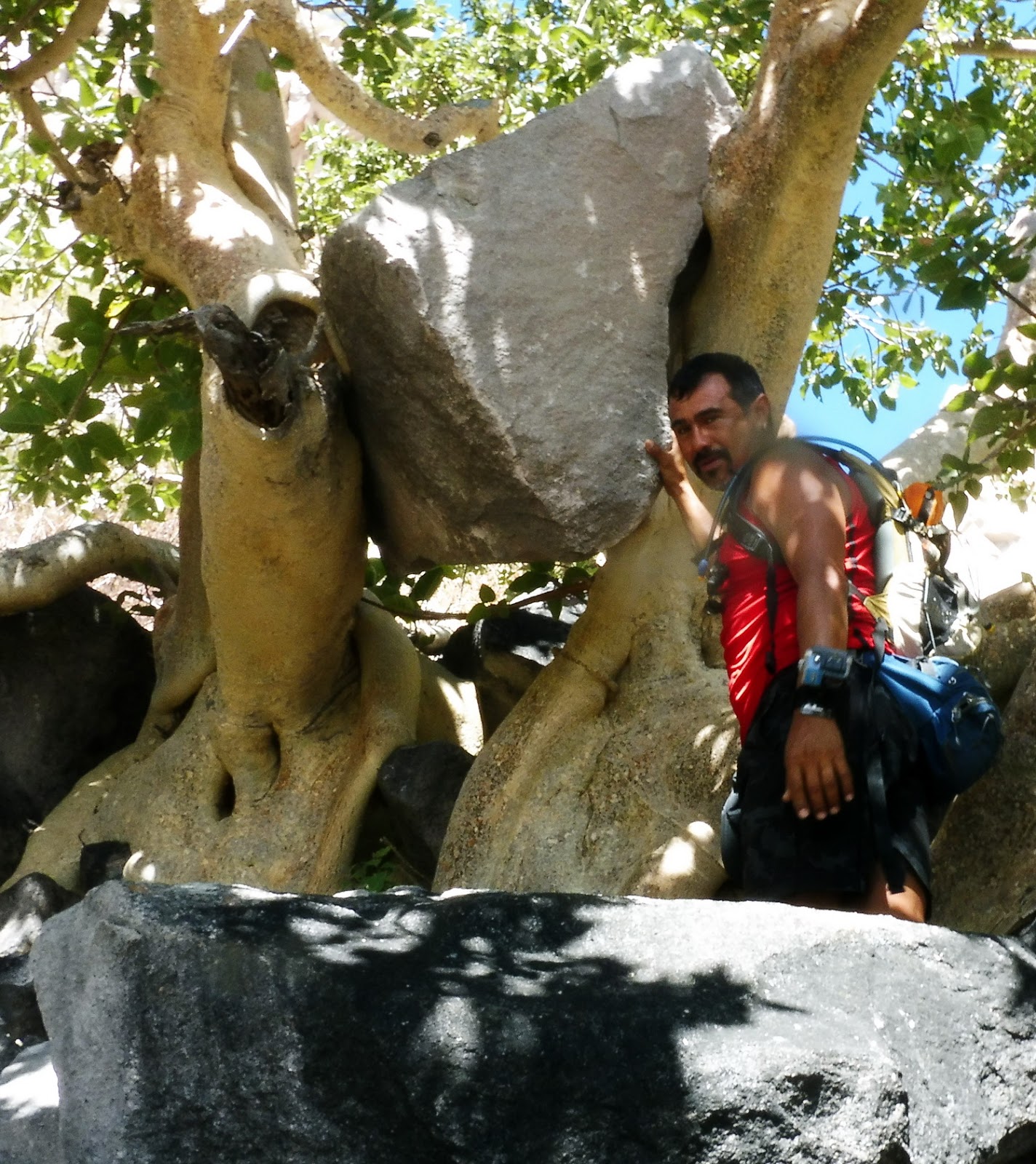
 The cloud cover has departed and the sun beats down on us, luckily the wind is still blowing. We stop for a rest in the shade of a huge fig tree, and are greeted with an incredible sight. A huge boulder, weighing at least 2 tons is wedged between two massive trunks of the tree, suspended four feet in the air. How did it get there? Did the tree lift it? We take a moment and marvel at the wonder of nature.

We continue our slow slog up the endless talus, finally reaching our first goal, the saddle. We are rewarded with incredible views of the Sierra Giganta, the valley below, the plateau to the west and the Sea of Cortez to the east and south.

We gaze up at the summit cone, it's steep walls of loose rock baring any possible ascent. Our only chance is from the north. We start scrapping our way along the base of the walls. The brush here is unrelenting, every piece of vegetation is primed to draw blood. After several hundred yards we reach a small clearing. The slope above us appears less intimidating. The route looks possible by doing several switchbacks rising up through several gullys.

We start up, the going is not as straight forward as we had hoped. The rock is all bad, just waiting to break off. We move cautiously, one at a time. The safest ways involve grappling through the thick brush. To avoid the brush means exposed climbing with questionable footing. The route now doesn't look as promising. Said and I go ahead looking for a way up. We reach what we hope will be a passable ridge, but this ends in a vertical cliff. On the cliff edge we find an abandoned back pack and water bottle. Who would have gotten this far and left their pack behind? Did they fall? We search for other signs of humans and see nothing.


We are about 150 feet from the summit, with no visible route from where we are. Our only alternative is to climb back down. It is getting too late in the day to look for an alternative. We are all tired and we know the way down will not be easy.

3 hours later we stumble to the car, bloody and beat. So close, yet so far. We crack a well deserved beer and gaze up at Lolita....   we tried, she won.     We will be back

Saturday, February 20, 2016

Santoro

One lofty goal we have on our agenda is to climb Cerro La Giganta, a massive 5,500 peak just north of Loreto. There are no trails and no good maps. Our friend Harry Morgan has had this on his "Bucket List" for a while, as has our friend Ed. We have all slowly collected bits of information from various locals, but now with the help of our good friend and local guide Said Orozco, we at least have a good interpreter. Harry's information has us starting the ascent at Rancho San Vicente, somewhere near the base of the mountain. So Wednesday morning, Harry, DeeDee, Said and I hop in Harry's 16 year old Nisson and head north.  We stop at the obligatory Military checkpoint, step out of the car for inspection. We make small talk with several of the young soldiers, they seem to enjoy the conversation. The two somewhat older officers try to act tough, but after a few jokes, they break as well. Not a fun job in 90 degree heat.


Just past the checkpoint we turn west into a large arroyo and follow a fairly good dirt track for several miles. After a wrong turn or two we pass several large water wells, these wells supply most of the water for Loreto. After about an hour, the road ends at Rancho San Vicente. We are greeted by a herd of healthy looking goats, a couple of small dogs and a german shepard. In the yard are peacocks, chickens, a few mules and cages of parakeets, which they raise and sell in town. At the casa we are welcomed by Ramona. Ramona and her husband Guillermo  have been living here, happily married  for 52 years.

Guillermo, she calls him Willy, is out pruning grape vines, but joins us shortly. He tells us of an old road that circles around some smaller hills and eventually leads to a large mesa, where it would be possible to camp. From there a days journey up to the summit and back to camp.

We agree to check out the road, we have no intention of climbing to the summit this day, but hopefully can find the route. As we pack up for our hike, the German Shepard, Santoro knows what we are up to and gets excited. He will be our guide today!

We follow the old track for about a mile, then turn left onto another road. This road has seen some use recently. We eventually drop down into a small arroyo with water, Santoro takes advantage and drinks up and plays in the cool stream. Soon the shallow stream deepens and our new friend pounces in and out of the pools. His favorite pastime, apparently, is diving down head first and bringing up rocks. We are amazed at the size of the rocks he can bring up from 3 or 4 feet of water.

A few miles later, we reach a clearing with an abandoned old rancho. There is gear neatly stashed under some Mesquite trees, possibly used for seasonal goat herding. The arroyo now turns into a steep walled canyon. The going from here on would be very difficult. We have lunch and conclude that this may not be the best approach, especially carrying large packs.

Back at Rancho San Vicente we tell Guillermo of our findings, he is pretty sure we were on the right track. We have a nice conversation and bid :Hasta Luego" to our hosts. Santoro is sound asleep on the cool shaded floor.

While we didn't exactly accomplish what we had hoped, it was still a great day in an awesome place, with fantastic people.

Tuesday, February 16, 2016

Beach Combing

Cabo and Cancun have beautiful white sandy beaches, Loreto does not.
Cabo and Cancun have Lots of high-rise hotels, condos and time shares, Loreto does not.
Cabo has McDonalds, KFC, Pizza Hut and Wal-Mart, Loreto does not,
Cabo and Cancun have street vendors selling trinkets at every corner, and barkers plying for your business, Loreto does not....

Loreto may not have the pristine beaches of other areas, but the beaches are endless and beautiful just the same. Miles and miles of beach without footprints, and the Islands are even more secluded. This is paradise for beach combers. Driftwood lines the high tide line, countless shells, star fish, sea glass and skeletons of unknown creatures litter the vast waterfront. Diligent beach combers can find countless treasures, like sea horses, rare shells, and artifacts from unlucky vessels.

The rewards are endless and each day's new tides brings new trophies.

Saturday, February 13, 2016

Comida Mexicana

Most of us New Englanders think of Mexican food as fajitas, chimichungas and crispy tacos with ground beef. In Baja, those foods hardly exist, except in the few places that cater to gringos.
Here in Loreto there are lots of restaurants and Taco Stands, all owned and operated by the owners, usually, just one family. In the smaller ones, the father will greet and seat you while mom does the cooking, the kids will bus the tables and wash the dishes. While many menus may seem similar, each is different. I've had chile renenos in ten different places and each is unique.

With fish, shrimp and the local chocolate clams plentiful, there is always fresh seafood dishes on the menu.

Twenty miles to the north is a fertile valley with much agriculture as it is 50 miles to the west on the Pacific side. As a result, fresh seasonal fruits and vegetables are regularly available, which is great as trucking in fresh produce from any further away is impractical here on the Baja. So while you cannot always get what you may want, what you do get is fresh and inexpensive.

Local beef is free range, and while a bit on the tough side, tasty. Excellent beef from Sonora is also readily available.

Locals don't really seem to  eat breakfast, but more of an early lunch. With the influx of Americans and Canadians, several restaurants offer  usual breakfast fare with some tasty Mexican additions, and always a nice fresh fruit plate and fresh squeezed OJ. Lunch for the locals is usually tacos, made with soft corn or wheat tortillas. chopped beef steak, fish, shrimp or birria, which is stewed goat meat or mutton or beef, quite good!

The options for dinner are numerous, from wood fired pizza, home made pasta, bar-b-que, and a few gourmet spots to many traditional Mexican eateries. Enchiladas, empanadas, chili rellenos and seafood. Chicken is also plentiful, and especially delicious is the pollo with mole sauce, a mildly spicy chocolaty sauce made with over 30 ingredients. Queso Burros, which are large flour tortillas filled  with beef or chicken, cheese, peppers and onions are outstanding. Tostados, and Volcans, crispy corn tortillas topped with piles of meat and fresh vegetables. One favorite of mine  is the Papa Relleno, a huge potato, baked over a wood fire, then stuffed with chopped aranchera beef, onions, corn and cheese and wrapped in foil and baked over the fire again.

Mexicans love their sweets, flan, of course, and many pastries and the local home made ice cream is particularly excellent!

As you may imagine, it's a bit tricky to watch your diet down here on the Baja!